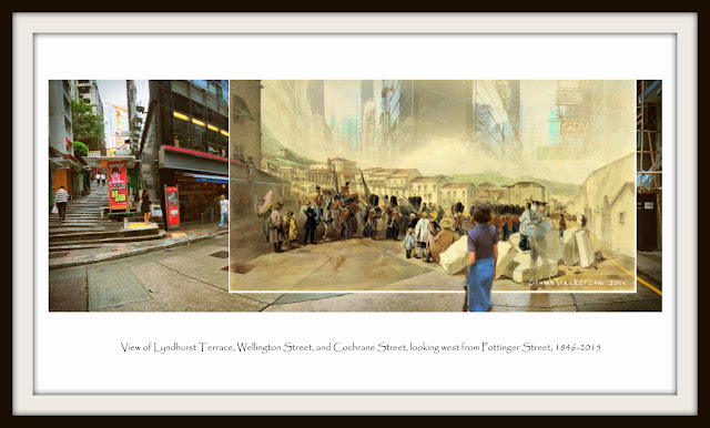
出巡 | Parade Query on Terrace
 |
| (Fig. 3a.) 出巡 | Parade Query on Terrace : 1846-2015 by Vincent Poon |
Murdoch Bruce 全景油畫,約1846年成畫。由今日砵甸乍街(Pottinger Street),向西望落閣麟街(Cochrane Street),這地方當年以背後的天主座堂為地標。士兵在儀仗領頭下,由遠方荷李活道(Hollywood Road),經油畫左邊的擺花街(Lyndhurst Terrace 麟檄士街)下山,再轉落威靈頓街(Wellington Street),向上環(Sheung Wan)的淺灘及下市場(Lower Bazaar)方向走。華人在旁看熱鬧,剛開埠,四處是建築石材,地面似泥濘所覆蓋。這全景仍可對照到今日現場,西歐油畫運用透視法,力求準繩,這幅是一例子。
擺花街英文Lyndhurst Terrace,稱得上為臺(Terrace),往往是幅地勢較緩和的山坡或山肩,地基稍加以平整,在上興建排屋。它是横直格局下的一個解決方案,縮短荷李活道與威靈頓街之間的距離。油畫左邊的樓房地基昇高,下面應是個石牆,婦人似在上晾晒閑聊。1920年代照片所見(fig 3c),街角仍保留著石牆。作畫時擺花街前,與威靈頓街之間,是個三角形的陡坡,由於仍然閑置空曠,所以見到閣麟街己先發展的排屋。大屋觀景一覽無遺,左邊背景數起,見到太平山,跟著遠眺大嶼山(Lantau Island)脊線。可以想像到,望落中上環大馬路海皮,華人中央街市(Central Market),海港船泊,以及對面海中國大陸。
 |
| (Fig. 3c.) View of Pottinger Street from Wellington Street and Lyndhurst Terrace, attributed to be 1920s. The building over stone wall was part of today's no. 2-10 Lyndhurst Terrace. |
油畫左邊為內陸41號地段,包括今日擺花街2至20號,以及砵典乍街33至35號所在地。在1843首批買地的時候,原屬同一份政府租契,而承租人是兩位女士,Emily Hudson 以及 Adeline Maria Hudson 分權共有(Tenants in Common)。這分權共有產權模式,與所謂「長命契」(聯權共有人Joint Tenant)不同,其中一方並沒有優先承繼另一方共有人權益的權利,即任何一方去世,其權益將根據其遺囑決定。
維多利亞時代女子,山長水遠,雙雙來到買地開荒或投機。當年香港被形容成為九反之地,通常外地人來港是男性商人或軍人,英籍婦孺一般都會是其家眷,即使是葡籍或華人婦女,亦是少數。香港名冊或渣甸書信等未見有兩人,即使同姓的記錄亦不多。
同名同姓,同代的英國當然會不少,但有相關連的,就有一對孻女,當年分別6及8歲姊妹,其父親名字 Nathaniel Hudson。這位Nathaniel Hudson,其後人只知於英屬印度從事律師,一家居於商港加爾葛答,其他細節不詳,他有位同名兄弟,只知死於1842。同樣兩人在一般文件未見有記錄,不過1845年Friend of China 有一則報導,一名德裔酒吧東主 Mr Christopher,因在軍部所開設酒吧出售劣酒,導至一名英國遠征軍第18團士兵Nathaniel Hudson死亡,最終被判罸100元。軍人在港出事,但快活谷未見有此人墓碑。會否於中國死去的士兵,就是Emily Hudson 以及 Adeline Maria Hudson 的叔父? 而印度當律師的Nathaniel Hudson,曾為兄弟死訊來港奔波?接近19世紀英國小說橋段。
內陸41號地段往後土地業權交易殘缺,只知沿擺花街2至20號土地分拆出售,曾保留砵甸乍街35號 。去到1869年,關於愛丁堡公爵(the Duke of Edinburgh)訪港報導中,描述有位律敦治先生(Mr. Ruttanjee),他座落於街角大屋,向西、北、及砵甸乍街三面均裝飾。
 |
| (Fig. 3f.): Point X was the spot Murdoch Bruce presumably stood at. Those blue lines were boundaries of selected lots in the neighborhood, during their own first land auction . Most of them would gradually dissect into fragmented lots in future transactions and developments. It was not until in today's day. The United Church on Staunton Street was erected on 1865, just as a reference to the following aerial photo. Those roman numbers intend to demonstrate landscape feature in the proximity. Numbers with a plus (+) are height in meter acquired from general government layout plan, where as other with a blanket are height acquired from Suuto device with roughly +/-2m variation. Note line of the spur from intersection of Hollywood Road and Lyndhurst Terrace eastbound. (Land Lot around 1840s to 1850s) |
 |
| (Fig. 3i.): "1845 Lt Collinson's Ordnance Survey" | A precise depiction of streets at Victoria. Note two stream courses ran down P&O / the Central Market thru Old Bailey and Peel Street |
維多利亞城(Victoria City)依山拾級而建,透過幾幅地圖中的地段標示,對比今日現場,中環最初的形成,不妨嘗試如此理解。
1841年城市規劃用作賣地時,內陸基本上用橫直線格局,當平面去分割土地(Fig 3g)。城內兩條主要公共街道皇后大道以及荷李活道,大體上東西方向平衡走,一個海皮,一個山上。荷李活道沿山勢宛然彎曲,此段於30米上下等高線開闢,開路者當走到將來大館位置,要繞過一個向海伸展的山嘴(Spur, Fig3f.)。
山嘴西坡於今日奧卑利街(Old Bailey)位置,原本有條山澗(Fig 3i),似乎流經今日閣麟街直落,或轉向結志街(Cage Street)跟卑利街(Peel Street)另一條溪流相遇。那處原規劃叫上市場(Upper Bazaar),即在吉土笠(Gutzlaff Street)到士他花利街(Stavaley Street)一帶,大至上是一幅地勢較緩,有溪流的落坡,當英國人建城,大批華工就湧到此聚居揾食。
山嘴東坡,再落山地勢似乎更加急陡。它跟東面無幾遠,港務官畢打署所(Harbour Master Pedder) 的山嘴並列,中間形成一個低谷,就是今日德忌笠街。
山嘴上的脊線,好自然,早被用作上落山的路徑。跟畢打山不同,規劃者在兩邊,均劃出士地於首拍推出,其中東坡威靈頓交界一幅,最後會用作天主教座堂,而山徑頂盡頭就會是大館,路尾隨發展未來是碼頭。這條沿脊線山徑,大概1850年代,冠名砵甸乍街。中環出海皮的公共街道是砵甸乍與畢打街,其餘的原則上是私人地段。城市發展到後來,公共系統不足應付的問題浮現,於是在興建中央街市時,將部份收回土地,劃出域多利皇后街(Queen Victoria Street)以及租庇利街(Jubilee Street),並於1895年啟用。
大馬路與荷李活道之間中線,主要街道是威靈頓街,它跟另一後街士丹利街,是由筆打山嘴西坡開始畫起,兩條街由東向西一直平衡走上,跨過砵甸乍脊線急落西坡。由於皇后大道跟海皮,在中央華人街市轉向西南彎曲,士丹利街走到上市場會完結,而威靈頓街穿越上市場一直落到尾,跟拗角的皇后大道交匯,那是臨海叫文咸的大淺灘(Bonham's Strand),亦是華商聚落下巿場(Lower Bazaar)。望過去,這淺灘大致伸延至水坑口,即1841年英軍正式登陸的另一彎角。
 |
| (Fig. 3j.): October View of Pottinger Street from Lyndhurst Terrace and Wellington Street, Hong Kong, 2014 (VP) |
 |
| (Fig. 3h.): View of Pottinger Street, Lyndhurst Terrace and Wellington Street, 2015 (VP) |
附註:
[1] Carl Smith Collection: "NATHANIEL HUDSON; 18TH [REGIMENT] 1845, card no. 111011"


Comments
Post a Comment